Traffic management
The street lamp whisperers
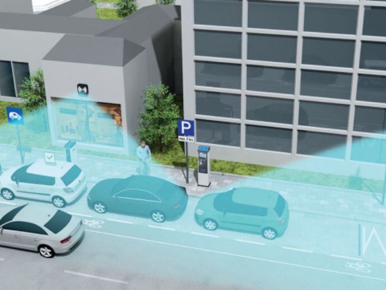
Sensor-Network Radar sensors mounted on street lamps continuously monitor parking spaces and report their vacancy status to a control centre. Photo: siemens.com/presse
A motorist’s dream could become reality: A smartphone app or the navigational device indicates where the next available parking space is located. Siemens is now testing, with a radar-supported sensor network, what is possible.
Anyone who is driving in a large city not only spends a lot of time driving; he also wastes time searching for a parking space. That comes to about 200 hours per driver per year. If, for example, a driver travels in Berlin from Potsdamer Platz to the Bundesallee, it takes him about 20 minutes – and then, typically, the same amount of time to find a place to park; during rush hour, that is. Upon arrival at the general vicinity, he frantically swerves from one side-street to another – as sung by the German pop-rock musician Herbert Grönemeyer – becoming a hazard for traffic behind him.
But all that could be changed in the near future. In a project funded by the Federal Ministry of Environment, Siemens wants to, together with several partners, reduce this annoying traffic caused by parking-space seekers. The method of choice is a sensor-controlled network that is built into street lamps, which is intended to eliminate the drivers’ search for a parking space. The test, initiated last September and lasting until spring 2016, involves equipping the street lamps along a 250 metre stretch of the Friedenauer Bundesallee with radar sensors and a WLAN unit. Each sensor scans an area of up to 30 metres and reports open parking spaces to a traffic-information centre. They in turn pass on the parking space information to the car’s navigation device or the driver’s smartphone app.
No more searching for parking spaces Marcus Zwick (left) and Florian Poprawa from Siemens AG test a system that can display parking spaces in real time. Photo: siemens.com/presse
The project partners selected the Bundesallee as a test location because it has, with its proximity to Steglitzer Schloßstraße with all of its department stores and shopping centres, a considerably higher density of parking-space-seeking traffic than other parts of the city. The system is conceivably simple for the drivers: They just have to enter the target location into their smartphone or their car’s navigation system, and the device shows immediately whether or not there is an open parking space available. In the event that the parking space becomes occupied during the approach time, alternatives in the vicinity are displayed – if there are any available. A special feature of the software is that it is operated by an adaptive system. It recognises whenever the park space situation repeats itself at certain times, and calculates predictions so that the user is better able to estimate what situation would await him upon arrival there. Moreover, if the system ascertains during the approach that there are no longer any parking spaces available at the target location, the integrated route planner calculates tips for alternative mobility variations – to the nearest U-Bahn or S-Bahn station, for example, from which the target can be reached without a search for a parking space.
In addition to Siemens, additional partners are involved in this project with the highly technical-sounding name City2.e 2.0: the Berlin Senate Department for Urban Development and the Environment, the Verkehrsmanagementzentrale Berlin (VMZ), the Institute for Climate Protection, Energy and Mobility, and the German Research Centre for Artificial Intelligence. They seek not only to create more services for the driver, but to help reduce the carbon-dioxide emissions within the inner city as well. This is because, according to their data, up to 30 percent of the inner-city traffic volume consists of parking-space seekers.
“But Siemens and their partners are not the first and only ones who want to offer parking information in real time,” says Peter Vortisch, Professor at the Institute for Transport Studies at the Karlsruhe Institute of Technology (KIT) in the Helmholtz Association – the app “Parkinfo” in Munich, “SF Park” in San Francisco, or the start-up “Schlauerparken.de” all have the same goal, but with different technical methods.
“Our platform is quite versatile,” solicits Marcus Zwick, Director of the Siemens Innovation Department for Mobility. By scanning from ten metres altitude, the exact outline of the parking space can be registered – thus providing information as well regarding whether the driver parked improperly by taking up two spaces or if his car represents a danger to other road users by blocking the bike lane, for example. “In the process it is also possible to advise the driver of this through the app or navigational system,” says Zwick. The radar system records not only the parking area, but the bordering street section as well and can recognise if traffic is moving along or standing still. The VMZ hence seeks to be able to indicate, in a future comprehensive deployment of the sensors, where a traffic jam exists along the way and possibly suggest possibilities for driving around it. The aim for the future is also that the system would be able to indicate whether charging stations for electric cars are free or occupied.
Detailed ascertainment of data through radar sensors would be unobjectionable from a data protection perspective, opines Zwick, since the radar image shows only general outlines of a car, thus not enabling recognition of the license plate or the vehicle model. But the platform is expandable in other areas as well: It can be connected with technical management of the parking space to determine precisely how long a car has been parked and whether the parking time-limit has elapsed. These data could be forwarded to the public order office, which then notifies an employee who can travel to the specific location to give the traffic offender a parking ticket.
Flexible monitoring also makes it possible to declare the entire street section and/or individual parking spaces as short-term no-parking zones during events, parades or shipments and subsequently release them.
“The advantage of the Siemens project is that it covers the entire chain from information collection to display system for the driver and also makes data available for traffic-guidance systems through the overhead sensors. Competing projects are not able to offer that,” says Peter Vortisch. The more dependable the information is that VMZ receives, the earlier one can initiate a diversion of traffic. In the final analysis, this is only capable of bringing about improved disbursement of the traffic – more parking spaces or wider streets could, of course, not be generated thereby.


Readers comments