Story #23
EnMAP – Space-based Environmental Mapping
The satellite mission EnMAP is setting new standards: its data allows global environmental changes to be analyzed – providing a basis of sound knowledge for combatting global change.
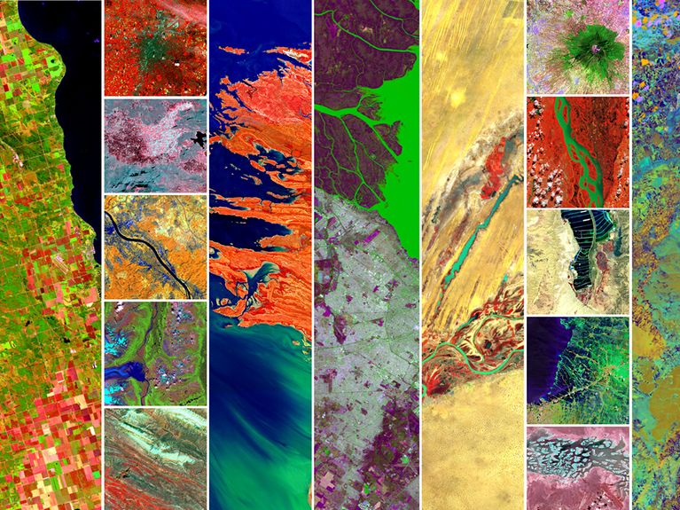
The German environmental satellite EnMAP (Environmental Mapping and Analysis Program) offers new perspectives on our planet. Its hyperspectral camera yields detailed insights into environmental processes, while also detecting changes that remain hidden from the human eye. Launched in April 2022, the satellite orbits Earth at an altitude of ca. 650 kilometers and continuously delivers valuable data for climate research, natural resource assessments, and environmental monitoring. It also monitors various forms of land use, e.g. agriculture, forestry and in urban areas.
To do so, it employs a spectrometer: every material on our planet’s surface reflects sunlight in a unique way – and EnMAP can measure these spectral signatures. The human eye and camera sensors only “see” in the three color channels red, green and blue. But EnMAP’s high-precision instrument can see in 224 channels, producing hyperspectral scans.
Using special analysis methods, the resulting images can be used to identify and confirm the materials and compositions of various land surfaces. With a spatial resolution of 30 meters per pixel, the satellite covers a 30-kilometer-wide and more than 5,000-kilometer-long strip of Earth’s surface every day. This precision makes it possible to accurately analyze the current status of ecosystems, agricultural areas, forests, bodies of water, and urban areas. In this way, EnMAP supports e.g. the monitoring of climate change impacts, early detection of soil degradation, and water-quality evaluations for inland and coastal waters.
Umweltsatellit EnMAP - Das Missionsvideo
For EnMAP, the German Aerospace Center (DLR) works closely with the GFZ Helmholtz Centre for Geosciences. The DLR’s German Space Agency coordinates the mission, while the GFZ provides scientific support. The satellite is operated by the DLR’s German Space Operations Center (GSOC) with the support of OHB, EnMAP’s manufacturer. Further DLR institutes provided key components like the camera system or are responsible for processing and preparing the data.
Working together, the team ensures that the EnMAP data meets the highest quality standards and is available to the scientific community – based on a partnership that combines the technological expertise and scientific know-how or all members.
EnMAP is an important step toward gaining a deeper understanding of Earth’s surface and the processes at work there, complementing the Helmholtz Association’s broad range of satellite-based projects. Given the outstanding data quality, the mission is setting new standards in Earth observation and environmental research. On this basis, it also delivers critical insights for the scientific and political communities – helping us combat climate change on a foundation of sound knowledge.
Picture: DLR
Participating centers